Toolbox
The toolbox is hidden by default. To show it, click Toolbox in the
View menu.
DX cluster
A DX cluster is essentially a server through which amateur radio operators can report and receive updates about QSOs that are in progress across the bands. PyQSO is able to connect to a DX cluster that operates using the Telnet protocol to provide a text-based alert service. As a result of the many different Telnet-based software products that DX clusters run, PyQSO currently outputs the raw data received from the DX cluster rather than trying to parse it in some way.
Click on Connect to Telnet Server then New... in the Connection menu, and enter the DX server
details in the dialog that appears. If no port is specified, PyQSO will
use the default value of 23. A username and password may also need to be
supplied. Frequently used servers can be bookmarked for next time; bookmarked server details are stored in ~/.config/pyqso/bookmarks.ini, where ~ denotes the user’s home directory.
Once connected, the server output will appear in the DX
cluster frame (see figure:dx_cluster). A command can also
be sent to the server by typing it into the entry box beneath the server output and clicking the
adjacent Send Command button (or pressing the Enter key).
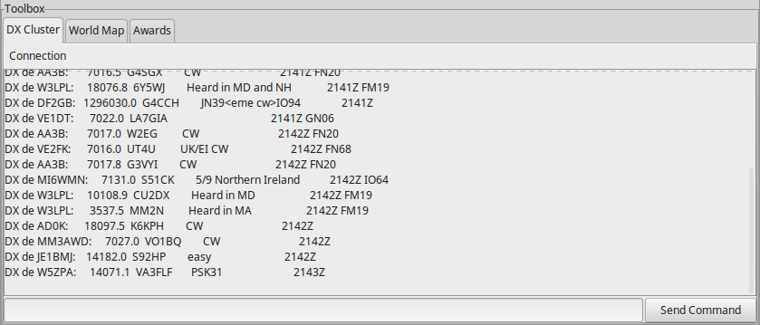
The DX cluster frame.
World map
The world map tool (see figure:world_map) can be used to plot the QTH of your station and stations that you have contacted. It also features a grey line to check which parts of the world are in darkness. The position of the grey line is automatically updated every 30 minutes.
The user’s QTH can be pinpointed on the map by specifying the QTH’s location (e.g. city name) and latitude-longitude coordinates in the preferences. If the geocoder library is installed then these coordinates can be filled in for you by clicking the lookup button after entering the QTH’s name, otherwise the coordinates will need to be entered manually.
The location of a worked station may also be plotted by right-clicking on the relevant QSO in the main window and selecting Pinpoint from the popup menu.
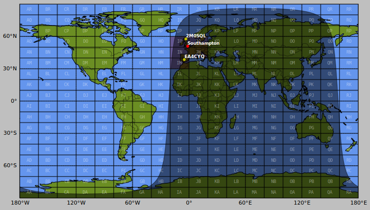
The world map tool with the user’s QTH (e.g. Southampton) pinpointed in red, and several other worked stations pinpointed in yellow. Worked grid squares are shaded purple.
Awards
The awards progress tracker (see figure:awards) updates its data each time a record is added, deleted, or modified. Currently only the DXCC award is supported (visit the ARRL DXCC website for more information).
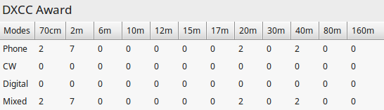
The award progress tracker.